War / Battle Map Alexandri Magni Expeditio
Sold by Harlan J. Berk, Ltd.
Description
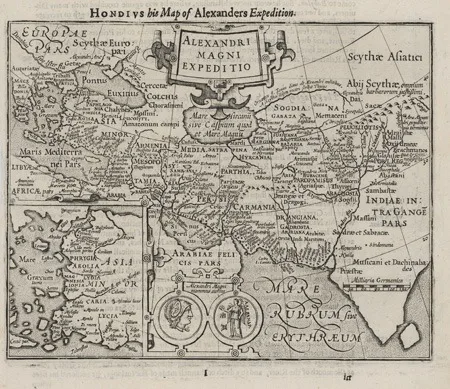
War / Battle Map Alexandri Magni Expeditio, 1625. An engraved historical map illustrating the campaigns of Alexander the Great, by Hondius, published in ""Purchase his Pilgrams"" by Samuel Purchas in 1625.
Designed as a visual narrative of conquest rather than a conventional geographic survey, the map traces Alexander’s eastward march from the eastern Mediterranean through Asia Minor, the Levant, Mesopotamia, Persia, and into India, plotting his route across a compressed Old World framework that unites Europe, Asia, and parts of Africa. Classical regional names dominate, reinforcing the map’s grounding in ancient historical geography.
Rivers, mountain ranges, and seas such as the Mare Rubrum and Mare Hyrcanum provide geographic structure, while an inset of the Aegean world offers greater regional detail. At the bottom of the map appear two medallions labeled “Alexandri Magni nummus aureus,” representing a gold coin of Alexander the Great. The imagery corresponds to Alexander’s gold stater type, with a helmeted head of Athena on one side and the goddess Nike standing on the other, serving as a visual emblem of imperial authority, victory, and royal legitimacy.
The text above the map summarizes episodes from Alexander’s campaign, including his ambitions, battles, hardships, and strategic decisions, while the verso continues the narrative with accounts of his return, death, and the naval expedition of Nearchus from the Indus to the Persian Gulf.
**Condition:** Map is in excellent condition presenting a strong print impression on lightly toned paper with no tears or holes. 6 x 7.5 inches (15.25 x 19. cm)..