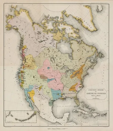
North America Map of Linguistic Stocks of American Indians Chiefly within the Present Limits of the United States by: John Wesley Powell
Sold by Harlan J. Berk, Ltd.
Sold on L5
Sign in to see what this coin sold for, free.
Description
North America Map of Linguistic Stocks of American Indians Chiefly within the Present Limits of the United States by: John Wesley Powell, 1890. This intriguing map of North America presents the linguistic reaches of various Native American tribes and nations throughout the continent. The map was prepared for the eleventh census of the United States and the information was garnered from the Annual Report of the Bureau of Ethnology.
Color coded by indigenous languages, the map provides very little in terms of physical topography or typical geopolitical information. Instead it provides an interesting glimpse into the vast reaches of some native tongues and the confinement of others. Such variances can be attributed to the topography, climate, and biodiversity of their land. Many tribes that spoke a variation of Algonquin or Siouan lived a more nomadic lifestyle, following herds across vast stretches of land. Other tribes along the west coast of America were more fixed to their land as much of their food came from the sea.
John Wesley Powell was a U.S. soldier, geologist, explorer of the American West. He is most known for the 1869 Powell Geographic Expedition, a three-month river trip down the Green and Colorado rivers, including the first official U.S. government-sponsored passage through the Grand Canyon. Powell served as second director of the U.S. Geological Survey from 1881 - 94. He became the first director of the Bureau of Ethnology at the Smithsonian Institution during his service as director of the U.S.G.S., where he supported linguistic and sociological research and publications.
**Condition:** This map is in very fine condition with subtle toning to the top left portion, which is more noticeable on the verso. Overall map colors are bright on clean paper with full margins on all sides. 20.5 x 17.5 inches (52 x 44.5 cm)..